Satellite Air Quality monitoring: Introduction to the NASA WorldView

Posted on February 15th 2015
Share: aqicn.org/faq/2015-02-15/satellite-air-quality-monitoring-introduction-to-the-nasa-worldview/

We recentely had the privilege to start a cooperation with the NASA Remote Sensing monitoring program.;

The objective is to use the Remote Air Quality sensing based on the NASA Satelites to determine the Air Quality in areas where sensors are not available (e.g. over the sea, but also for countries where sensors are not yet available).


At first glance, the remote satellite sensing theory and the algorithms needed to process this huge-data seems a bit barbarian for non-scientist, having to handle, for instance, data sets like the Aerosol Optical Depth (aka AOD) and Aerosol Optical Thickness (aka AOT). But, actually, the NASA did an excellent work at making the data very easy to use and understand by anyone, but also freely available (in public domain)!

There are many topics we are going to be writing about the use of the satellite data, along with our cooperation with the NASA ARSET program. But to start with, we want to introduce one of their products called the world-view, which is so easy and intuitive to use, and so much worth beeing known by every one. The very nice feature of worldview is the ability to provide historical view, so that you can check the data for any day in the past few years (and, again, for free).

The picture below is dated from Janurary 14th, and shows the Modis Aqua layer together with the Fire and Thermal Anomalies (plotted as red spots). For people leaving in Singapore, this view might be common since the Singapore EPA is providing Satellite hotspot monitoring, especially to monitor fires from Indonesia.
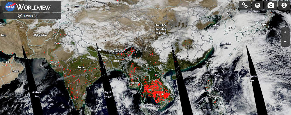


Same image available from the NASA world view server: https://earthdata.nasa.gov/labs/worldview/

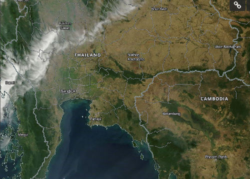
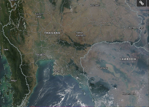
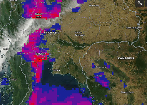
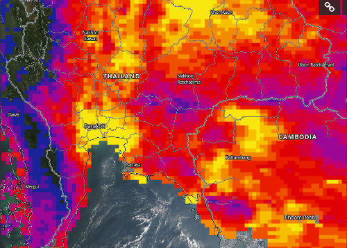
This is other set of snapshots show a comparative view of Thailand and Cambodia for two days. One with an almost clear sky (on the left), and the other one with a visible haze (on the right). By using the Aerosol Optical Depth (AOD) overlay (snapshots at the bottom), the zones detected as the most hazy are highlighted with red to yellow color. Comparing the top and bottom snapshots, there is no doubt that using the AOD is the right way to detect the pollution, and thereby determine the quantity of PM2.5 in the air. That's something we will write very soon about.


Januray 16th 2015 - Clear sky over Cambodia
February 11th 2015 - Visible Haze over Cambodia

Same images with the AOD overlay (yellow: thick haze - red: medium haze - blue: light haze)

Please note that what looks like haze does not always particule matter - PM2.5 pollution. Haze can be mix of smoke, dust and pollution. In some case (see this article) it can also be due to humidity.

oOo

One limitation of the satellite data is that it is available only on a daily basis (instead of hourly for ground monitoring), and that it does not work with cloudy sky (obviously, the satellite can't see though the clouds, at least for Aqua and Terra). But even, despite those limitations, it is a great tool with so many possibilities: Providing data for countries without sensors, providing a source for global and worldwide air quality forecast, ...

Click here to see all the FAQ entries
  • AQI Scale: What do the colors and numbers mean?
  • Using Statistical Distances for Real-time Sensor Networks Validation
  • Nitrogen Dioxyde (NO2) in our atmosphere
  • About the Air Quality and Pollution Measurement:

    About the Air Quality Levels

    AQIAir Pollution LevelHealth ImplicationsCautionary Statement (for PM2.5)
    0 - 50GoodAir quality is considered satisfactory, and air pollution poses little or no riskNone
    51 -100ModerateAir quality is acceptable; however, for some pollutants there may be a moderate health concern for a very small number of people who are unusually sensitive to air pollution.Active children and adults, and people with respiratory disease, such as asthma, should limit prolonged outdoor exertion.
    101-150Unhealthy for Sensitive GroupsMembers of sensitive groups may experience health effects. The general public is not likely to be affected.Active children and adults, and people with respiratory disease, such as asthma, should limit prolonged outdoor exertion.
    151-200UnhealthyEveryone may begin to experience health effects; members of sensitive groups may experience more serious health effectsActive children and adults, and people with respiratory disease, such as asthma, should avoid prolonged outdoor exertion; everyone else, especially children, should limit prolonged outdoor exertion
    201-300Very UnhealthyHealth warnings of emergency conditions. The entire population is more likely to be affected.Active children and adults, and people with respiratory disease, such as asthma, should avoid all outdoor exertion; everyone else, especially children, should limit outdoor exertion.
    300+HazardousHealth alert: everyone may experience more serious health effectsEveryone should avoid all outdoor exertion

    To know more about Air Quality and Pollution, check the wikipedia Air Quality topic or the airnow guide to Air Quality and Your Health.

    For very useful health advices of Beijing Doctor Richard Saint Cyr MD, check www.myhealthbeijing.com blog.


    Usage Notice: All the Air Quality data are unvalidated at the time of publication, and due to quality assurance these data may be amended, without notice, at any time. The World Air Quality Index project has exercised all reasonable skill and care in compiling the contents of this information and under no circumstances will the World Air Quality Index project team or its agents be liable in contract, tort or otherwise for any loss, injury or damage arising directly or indirectly from the supply of this data.


    Settings


    Language Settings:


    Temperature unit:
    Celcius