measured by South African Air Quality Information System - SAAQIS.
Values are converted to the US EPA AQI standard.")
 measured by South African Air Quality Information System - SAAQIS.
Values are converted to the US EPA AQI standard.")
 measured by South African Air Quality Information System - SAAQIS.
Values are converted to the US EPA AQI standard.")
 measured by South African Air Quality Information System - SAAQIS.
Values are converted to the US EPA AQI standard.")
 measured by South African Air Quality Information System - SAAQIS.
Values are converted to the US EPA AQI standard.")
 measured by Citizen Weather Observer Program (CWOP/APRS).")
 measured by Citizen Weather Observer Program (CWOP/APRS).")
 measured by Citizen Weather Observer Program (CWOP/APRS).")
 measured by Citizen Weather Observer Program (CWOP/APRS).")
大気汚染予測

空気質データの提供元: the South African Air Quality Information System - SAAQIS (saaqis.environment.gov.za)

空気質データの提供元: the South African Air Quality Information System - SAAQIS (saaqis.environment.gov.za)
| または最寄りのモニタリングステーションを検索 |
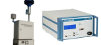
当社の GAIA 空気質モニターはセットアップが非常に簡単です。必要なのは、Wi-Fi アクセス ポイントと USB 対応の電源だけです。
接続すると、リアルタイムの大気汚染レベルが地図上および API を通じて即座に確認できるようになります。
ステーションには、10 メートルの防水電源ケーブル、USB 電源、取り付け装置、オプションのソーラー パネルが付属しています。
| 指数 | 大気質指数の分類(米国) | 健康影響 / カテゴリ | 粒子状物質(PM10,PM2.5) |
| 0 - 50 | 良い - Good | 通常の活動が可能 | なし |
| 51 -100 | 並 - Moderate | 特に敏感な者は、長時間又は激しい屋外活動の減少を検討 | 非常に敏感な人は、長時間または激しい活動を減らすよう検討する必要がある。 |
| 101-150 | 敏感なグループにとっては健康に良くない - Unhealthy for Sensitive Groups | 心臓・肺疾患患者、高齢者及び子供は、長時間又は激しい屋外活動を減少 | 心疾患や肺疾患を持つ人、高齢者、子供は、長時間または激しい活動を減らす必要がある。 |
| 151-200 | 健康に良くない - Unhealthy | 上記の者は、長時間又は激しい屋外活動を中止 すべての者は、長時間又は激しい屋外活動を減少 | 心疾患や肺疾患を持つ人、高齢者、子供は、長時間または激しい活動を中止する必要がある。それ以外の人でも、長時間または激しい活動を減らす必要がある。 |
| 201-300 | 極めて健康に良くない - Very Unhealthy | 上記の者は、すべての屋外活動を中止 すべての者は、長時間又は激しい屋外活動を中止 | 心疾患や肺疾患を持つ人、高齢者、子供は、全ての屋外活動を中止する必要がある。それ以外の人でも、長時間または激しい活動を中止する必要がある。 |
| 300+ | 危険 - Hazardous | 上記の者は、屋内に留まり、体力消耗を避ける すべての者は、屋外活動を中止 | 全ての人が屋外活動を中止する必要がある。特に、心疾患や肺疾患を持つ人、高齢者、子供は、屋内に留まって激しい活動を避け静かに過ごす必要がある。 |
Celsius |