measured by Citizen Weather Observer Program (CWOP/APRS).")
 measured by Citizen Weather Observer Program (CWOP/APRS).")
空氣質量預報

空氣品質數據提供者: the Office of Environment and Heritage - NSW (environment.nsw.gov.au)
空氣品質數據提供者: the Office of Environment and Heritage - NSW (environment.nsw.gov.au)
| 或者查找最近的監測站 |
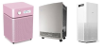
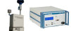
我們的 GAIA 空氣品質監測儀設定非常簡單:您只需要一個 WIFI 存取點和一個 USB 相容電源。
連接後,您可以透過地圖和 API 立即獲得即時空氣污染等級。
該站配有 10 公尺長的防水電源線、USB 電源、安裝設備和可選的太陽能電池板。
| 空气质量指数 | 空气质量指数级别(状况)及表示颜色 | 对健康影响情况 | 建议采取的措施 |
| 0 - 50 | 一级(优) | 空气质量令人满意,基本无空气污染 | 各类人群可正常活动 |
| 51 -100 | 二级(良) | 空气质量可接受,但某些污染物可能对极少数异常敏感人群健康有较弱影响 | 极少数异常敏感人群应减少户外活动 |
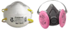
| 101-150 | 三级(轻度污染) | 易感人群症状有轻度加剧,健康人群出现刺激症状 | 儿童、老年人及心脏病、呼吸系统疾病患者应减少长时间、高强度的户外锻炼 |
| 151-200 | 四级(中度污染) | 进一步加剧易感人群症状,可能对健康人群心脏、呼吸系统有影响 | 儿童、老年人及心脏病、呼吸系统疾病患者避免长时间、高强度的户外锻炼,一般人群适量减少户外运动 |
| 201-300 | 五级(重度污染) | 心脏病和肺病患者症状显著加剧,运动耐受力降低,健康人群普遍出现症状 | 儿童、老年人及心脏病、肺病患者应停留在室内,停止户外运动,一般人群减少户外运动 |
| 300+ | 六级(严重污染) | 健康人群运动耐受力降低,有明显强烈症状,提前出现某些疾病 | 儿童、老年人和病人应停留在室内,避免体力消耗,一般人群避免户外活动 |
Celsius |